
October 5, 2026 · Commute Guide
Rocky River vs. Lakewood: The Route 2 West Shoreway Commute Fact-Check
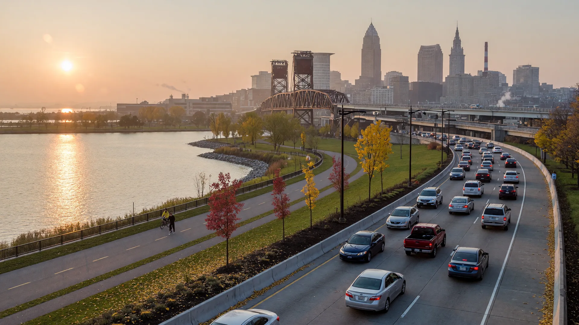
Rocky River and Lakewood are the two lakefront suburbs that anchor the west end of the Route 2 Cleveland Memorial Shoreway, and both put downtown Cleveland within a 15 to 30 minute morning drive. Lakewood is the closer of the two at roughly 7 miles and 10 to 15 minutes off-peak, while Rocky River sits about 9 to 11 miles out at 13 to 17 minutes off-peak. The catch is the Shoreway itself: the roughly $100 million Lakefront West project rebuilt the west segment as a 35 mph signalized boulevard by 2018, and the Main Avenue Bridge lane pinch at the Cuyahoga River is where the morning queue forms. Here is the street-level fact-check, with published drive times, transit schedules, and 2026 price and tax data for both cities.
Where exactly is the Route 2 West Shoreway, and what changed after the Lakefront West project?
State Route 2 enters Cleveland as the Cleveland Memorial Shoreway, a limited-access lakeshore corridor that splits into an east segment and a west segment. The west segment runs from the Main Avenue Bridge over the Cuyahoga River westward roughly three miles to Clifton Boulevard and Lake Avenue at the Lakewood line, where it continues as the Edgewater Parkway, formally the Governor Richard F. Celeste Shoreway. This is the stretch every Lakewood and Rocky River commuter drives twice a day.
The road changed character between 2015 and 2018. The Lakefront West project, reported at roughly $100 million, converted the west segment from a 50 mph freeway into a landscaped 35 mph boulevard with signalized, at-grade intersections, a multi-use path, and direct connections to Edgewater Park. The speed limit dropped to 40 mph when construction began in June 2015 and then to a permanent 35 mph. One analysis of the finished road called it an odd compromise: a landscaped roadway still designed for highway speeds. For commuters the practical effect is simple: the Shoreway is no longer a free-flowing highway, and a red light or a fender-bender now stops the whole corridor.
The exits matter for where you land downtown. Westbound, Exit 194 at West 28th Street serves the Flats West district and is a left-hand exit, which adds weaving for drivers unfamiliar with the corridor. Eastbound, the West 25th Street exit is where U.S. Routes 6 and 20 leave SR 2, and it drops you at the edge of Ohio City and the West Side Market. The Detroit-Superior Bridge, also called the Veterans Memorial Bridge, is the 3,112-foot through-arch span that carries U.S. 6/20 between Detroit Avenue and Superior Avenue downtown, which is why Shoreway commuters headed to the west side of downtown often take the West 25th Street exit rather than continuing to the inner belt.
How long is the morning commute from Rocky River and Lakewood into downtown Cleveland?
Published drive-time estimates put Lakewood at about 7 miles and 10 to 15 minutes from downtown off-peak, and Rocky River at 9 to 11 miles and roughly 13 to 17 minutes off-peak, with route services citing 13 to 16 minutes for the Rocky River run. The morning rush in the Cleveland metro runs roughly 7:30 to 9:00 a.m., heaviest between 8:00 and 8:30, and the metro-wide average commute is about 25 minutes. On the Shoreway specifically, peak-hour drives typically run 5 to 10 minutes longer than off-peak times, and during incidents and construction windows commuters have reported backups stretching back past West 108th Street with drive times that roughly doubled.
Table: Estimated commute times from Lakewood and Rocky River to downtown Cleveland by car and by RTA 55 Clifton bus, with 2026 median sale price context. Drive times are published estimates for typical conditions; peak ranges reflect the Shoreway's known congestion. Prices are Redfin and Movoto reported medians, accessed October 5, 2026.
| Community | Miles to Downtown | Off-Peak Drive | Morning Peak Drive | RTA 55 Clifton Bus | 2026 Median Sale Price |
|---|---|---|---|---|---|
| Lakewood | ~7 mi | 10-15 min | 15-25 min | ~15-25 min | ~$349K |
| Rocky River | ~9-11 mi | 13-17 min | 20-30 min | ~28 min | ~$306K-$318K |
A few notes on the numbers. Lakewood's range is wider because the city runs more than four miles along the lakefront: homes at the eastern edge near Clifton Boulevard are a short drive from downtown, while the western end near the Rocky River border adds several minutes. Rocky River's off-peak window of 13 to 17 minutes comes from published route and ride estimates, and the peak window assumes the Shoreway's typical queue at the Main Avenue Bridge. Both cities sit well inside the metro average commute of about 25 minutes, which is the point most buyers miss: the Shoreway bottleneck is real, but it is a 5 to 10 minute tax on a drive that is still among the shortest in the region.
Why does the West Shoreway bottleneck, and where does the queue actually form?
The morning queue forms at the Main Avenue Bridge, the eastbound crossing of the Cuyahoga River where the Shoreway narrows and merges with traffic from the inner belt. The bridge has been the corridor's lane-narrowing chokepoint for years: during the 2018 construction season, eastbound traffic was cut to a single lane and backups became a daily headline. Even outside construction, the merge at the bridge compresses three lanes of Shoreway traffic into the downtown approach.
The boulevard conversion added a second, permanent friction point. Signalized intersections on the west segment mean the corridor no longer absorbs a stall the way a freeway does, and the left-hand West 28th Street exit adds weaving for westbound drivers. At the east end, the Shoreway feeds into I-90 near downtown, and the merge zone around the curve known as Dead Man's Curve plus the left exits add delay for drivers continuing past the central business district. The practical takeaway for homebuyers: the bottleneck is concentrated at the bridge and the downtown merge, so the last two miles of the drive matter more than the first ten.
What do the 2026 numbers say about Rocky River vs. Lakewood home prices?
The 2026 medians run counter to what most out-of-town buyers expect. Lakewood's reported median sale price is roughly $349,000 on Redfin's most recent three-month window, up about 7.5 percent year over year, with PropertyFocus reporting a median near $336,550 in September 2026. Rocky River's reported median sits lower, around $306,400 on Movoto's February 2026 data and about $318,000 on Redfin's early 2026 figure, down roughly 11 percent year over year. Median value estimates from other sources run higher for both cities, so treat any single number as directional and check recent sales in the specific block.
Table: 2026 price and tax comparison for Lakewood and Rocky River. Sale medians are Redfin, Movoto, and PropertyFocus reported figures, accessed October 5, 2026. Tax rates are from the City of Rocky River, RITA, the City of Lakewood, and Cuyahoga County tax schedules for the most recent published tax years. Treat medians as directional, not appraisals.
| City | 2026 Median Sale Price | 12-Month Trend | Effective Property Tax | City Income Tax | Income Tax Credit |
|---|---|---|---|---|---|
| Lakewood | ~$349K | Up ~7.5% YoY | ~2.25% of market value | 1.5% | 50% credit, up to 1.0% |
| Rocky River | ~$306K-$318K | Down ~11% YoY | ~1.93% of market value (134.00 mills) | 2.0% | 100% credit, up to 1.5% |
The housing stock explains part of the price gap. Lakewood is the denser city, with a large share of multi-family buildings, bungalows, and walkable commercial streets, which keeps entry prices lower per square foot. Rocky River skews toward single-family homes on larger lots, with lakefront and riverfront inventory that carries premiums, and its median value estimates run near $350,000 even when sale medians dip. Neither statement is a judgment on quality; it is a structural difference that changes what your money buys.
How do property taxes and city income taxes compare in Rocky River and Lakewood?
Both cities sit in Cuyahoga County, but their tax structures differ in ways that matter to a monthly budget. Rocky River carries a total real property rate of 134.00 mills for tax year 2025, payable in 2026, which works out to an effective rate of roughly 1.93 percent of market value, and its city income tax is 2.0 percent, collected by the Regional Income Tax Agency (RITA) since January 1, 2016, with a 100 percent credit factor capped at a 1.50 percent credit rate. Lakewood's effective property tax rate is roughly 2.25 percent of market value, its city school district voted rate was 165.16 mills for tax year 2024, and its city income tax is 1.5 percent with a 50 percent credit capped at 1.0 percent.
The credit structure is the part buyers usually overlook. A Lakewood resident who works in Cleveland, where the income tax is 2.5 percent, credits only half of Lakewood's 1.5 percent tax up to a 1.0 percent cap, so the work-city tax fills the gap. A Rocky River resident gets a 100 percent credit up to 1.5 percent against taxes paid to a work city. The effective burden depends on where you work, not just where you live, so the comparison is only meaningful with your actual work address in hand. This is general education, not tax advice: verify the current rates and credit rules with RITA, the cities, and a qualified tax professional.
What about transit: which RTA bus actually runs on the Shoreway?
The bus that uses the Shoreway is the RTA 55 Clifton, which runs from downtown's Stephanie Tubbs Jones Transit Center at Tower City out the Memorial Shoreway to Clifton Boulevard through Cleveland and Lakewood, then Detroit Road to Wagar Road in Rocky River, ending at the Westgate Transit Center. Published schedules put the Rocky River-to-downtown ride at about 28 minutes and the Lakewood ride at roughly 15 to 25 minutes depending on the stop. The RTA 26/26A Detroit line, by contrast, runs on Detroit Avenue, not the Shoreway, and takes about 35 to 40 minutes from Lakewood and about 40 minutes from the Rocky River loop. The distinction matters if you are comparing transit commutes: the 55 is the lakefront express, and the 26 is the slower inland route.
Practical buyer and seller takeaways
For buyers. Test the drive at the time you will actually make it, not on a weekend. The Shoreway at 8:00 a.m. is a different road than the Shoreway at 2:00 p.m., and the queue at the Main Avenue Bridge is the part a Saturday test drive will miss. If your office is downtown, map the door-to-badge route from the specific address: Lakewood's eastern edge near Clifton Boulevard behaves like a near-downtown neighborhood, while the western end behaves more like Rocky River. And run the income tax credit math with your actual work city before you pick a side of the city line.
For sellers. Price against your city's median, not the metro average. A Lakewood listing competes with other Lakewood inventory near $349,000, while a Rocky River listing competes near the low to mid $300,000s, and buyers researching both cities will know the difference. In our experience, listing a home with the actual door-to-downtown drive time in the description draws more serious buyers than a generic "minutes from downtown" line, because commute data is what out-of-town buyers search for first.
In our experience helping buyers weigh the two lakefront suburbs, the price direction is the first thing that surprises out-of-town buyers: Lakewood's reported median sale price has run ahead of Rocky River's for much of 2026, even though Rocky River carries a higher city income tax rate and higher total property millage. The commute math cuts the other way. Rocky River trades roughly 5 to 10 extra minutes at peak for more single-family inventory and larger lots, while Lakewood's denser street grid puts more homes within a short drive of the West 25th Street exit. We map the door-to-badge route at the time a buyer will actually drive it before the first showing, because the Shoreway at 8 a.m. and the Shoreway at 2 p.m. are two different commutes.
For the full relocation picture, see our moving to Northeast Ohio guide, our Cleveland and Northeast Ohio region page, and our Cleveland condos vs. townhomes guide for the downtown and Ohio City inventory picture.
Frequently Asked Questions
Is the West Shoreway still a freeway, or did it become a boulevard?
The west segment of the Route 2 Shoreway is now a 35 mph boulevard. The Lakefront West project, reported at roughly $100 million and built from 2015 to 2018, converted the stretch from the Main Avenue Bridge to Clifton Boulevard and Lake Avenue from a 50 mph freeway into a landscaped road with signalized intersections, a multi-use path, and Edgewater Park connections. The Main Avenue Bridge crossing the Cuyahoga River remains the corridor's lane-narrowing chokepoint.
How long does it take to drive from Rocky River to downtown Cleveland in morning traffic?
Off-peak, published estimates put the Rocky River drive at roughly 13 to 17 minutes over 9 to 11 miles. At morning peak, expect 20 to 30 minutes, with the extra time concentrated at the Main Avenue Bridge merge and the downtown I-90 approach. During incidents and construction windows, commuters have reported backups past West 108th Street and drive times that roughly doubled.
Which is closer to downtown Cleveland, Lakewood or Rocky River?
Lakewood is closer, at roughly 7 miles and 10 to 15 minutes off-peak, because it borders Cleveland directly. Rocky River sits about 9 to 11 miles out at 13 to 17 minutes off-peak. Both stay inside the metro-wide average commute of about 25 minutes, and the Shoreway bottleneck adds roughly 5 to 10 minutes at peak for both cities.
Does the RTA 55 Clifton bus run along the Shoreway?
Yes. The 55 Clifton runs from downtown's Tower City transit center out the Memorial Shoreway to Clifton Boulevard through Cleveland and Lakewood, then Detroit Road to Wagar Road in Rocky River, ending at Westgate Transit Center. Published schedules put the Rocky River-to-downtown ride at about 28 minutes and the Lakewood ride at roughly 15 to 25 minutes. The 26/26A Detroit line runs on Detroit Avenue instead and takes about 35 to 40 minutes.
How do property taxes compare between Rocky River and Lakewood?
Rocky River's total real property rate is 134.00 mills for tax year 2025, payable in 2026, an effective rate of roughly 1.93 percent of market value, with a 2.0 percent city income tax collected by RITA. Lakewood's effective property tax rate is roughly 2.25 percent of market value, with a 1.5 percent city income tax. The income tax credit structures differ too, so the real burden depends on where you work. Verify current rates with the cities, RITA, and a tax professional.
Is Lakewood or Rocky River more affordable in 2026?
Reported 2026 medians put Lakewood near $349,000, up about 7.5 percent year over year, and Rocky River near $306,000 to $318,000, down roughly 11 percent year over year. Median value estimates from other sources run higher for both cities, and the housing mix differs, so any single number is directional. Check recent sales in the specific block with a local agent before drawing a conclusion.
Sources
- AARoads: State Route 2, Cleveland Memorial Shoreway (West)
- WKYC: Lakefront West Shoreway project near completion (2018)
- cleveland.com: West Shoreway speed limit drops to 35 mph (2015)
- cleveland.com: West Shoreway bridge down to one lane (2018)
- Greater Cleveland RTA: 55-55B-55C Clifton route
- Greater Cleveland RTA: 26-26A Detroit route
- City of Rocky River: Finance Department (tax rates)
- Regional Income Tax Agency (RITA): Rocky River member page
- City of Lakewood: Tax FAQs
- Cuyahoga County: Tax Rates by Community, TY24/CY25
- Redfin: Rocky River housing market data
- Redfin: Lakewood housing market data
- Movoto: Rocky River market trends
- Rome2Rio: Rocky River to Cleveland route estimates
Reporting period: Lakefront West project coverage, ODOT and GCRTA route records, city and RITA tax rate tables, Cuyahoga County tax schedules, and published 2026 price reports, accessed October 5, 2026. This guide is general market education, not legal, tax, financial, or mortgage advice. Verify current traffic conditions, tax rates, and credit rules with ODOT, RITA, the cities, and qualified professionals for your specific situation.
Social caption: New commute fact-check: Rocky River vs. Lakewood along the Route 2 West Shoreway. Real drive times, the 35 mph boulevard rebuild, the Main Avenue Bridge bottleneck, RTA 55 bus times, and 2026 price and tax data for both lakefront suburbs. Link in bio. #ClevelandRealEstate #Shoreway #LakewoodOH #RockyRiverOH #GlasshouseRealty
Published October 5, 2026 · Updated October 5, 2026
Weighing the Shoreway commute?
Tell us your work address and your budget, and we will map the morning drive from Lakewood, Rocky River, and every stop in between before you look at a single home. No pressure, just data you can drive to.
Talk to an AgentMapping your Cleveland commute?
Whether you are buying, renting, or just weighing the Lakewood versus Rocky River trade-off, a Glasshouse agent can map your drive time, your budget, and your timeline in one conversation.
We help buyers compare commute corridors across Northeast Ohio every week, from Lakewood bungalows to Rocky River lakefront.
Schedule a Consultation